
Pike National Forest
Description
Sentiers de cette région
Liens
Données
Rapports
Guides et cartes
Hébergement
Organisations
Voyagistes
GPS
Autre
Livres

Stanfords
United Kingdom
United Kingdom
- Waldviertel North - Gmund - Heidenreichstein - Waidhofen & Raabs a.d.T. - Trebon F&B WK075
- Waldviertel North - Gmünd - Heidenreichstein - Waidhofen a.d.T. - Raabs a.d.T. – Trebon area of eastern Austria presented at 1:50,000 in a series of contoured and GPS compatible outdoor leisure map from Freytag & Berndt with hiking and cycling routes, mountain huts, campsites and youth hostels, local bus stops, plus other tourist information.To... Lire la suite

The Book Depository
United Kingdom
United Kingdom
- Uphill Both Ways
- Hiking toward Happiness on the Colorado Trail Lire la suite

The Book Depository
United Kingdom
United Kingdom
- What We Owe to Ourselves
- a 500-mile hike on the Colorado Trail Lire la suite

The Book Depository
United Kingdom
United Kingdom
- Purpose on the Colorado Trail
- (Black and White Version) Lire la suite

The Book Depository
United Kingdom
United Kingdom
- Colorado Trail [map Pack Bundle]
- Topographic Map Guides; Trails Illustrated Maps Lire la suite


Bol.com
Netherlands
Netherlands
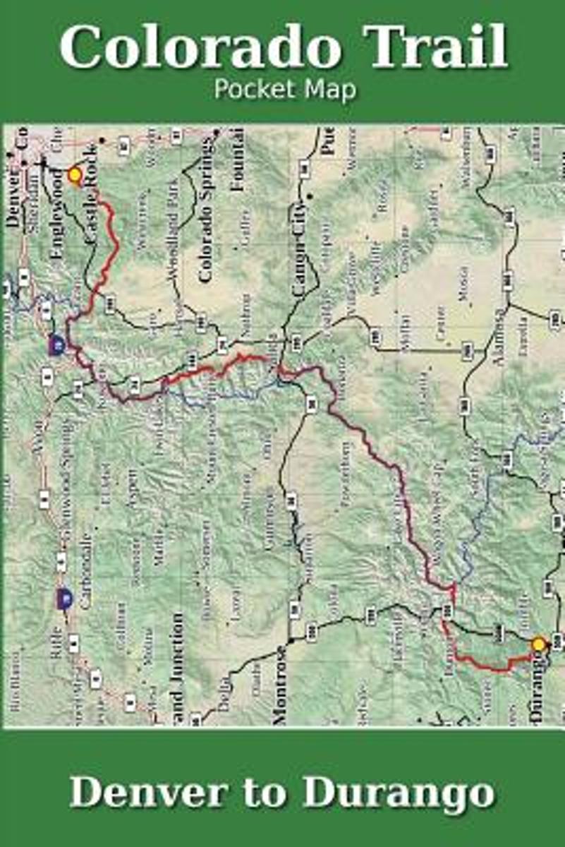
- Colorado Trail Pocket Map
- The Colorado Trail Pocket Map is a complete and concise set of topographic maps created with digitized base maps covering every step of the 482 mile trail from Denver, CO to Durango, CO.The land cover, hydrology and contour data used to create these maps has been collected within the last 5 years, presented in a completely uniform manner across... Lire la suite
- Also available from:
- Bol.com, Belgium
Bol.com
Belgium
Belgium
- Colorado Trail Pocket Map
- The Colorado Trail Pocket Map is a complete and concise set of topographic maps created with digitized base maps covering every step of the 482 mile trail from Denver, CO to Durango, CO.The land cover, hydrology and contour data used to create these maps has been collected within the last 5 years, presented in a completely uniform manner across... Lire la suite

Bol.com
Netherlands
Netherlands
- Gravel Cycling
- Head out for adventure on the unpaved back roads of America with Nick Legans complete guide to gravel grinders and bikepacking!Gravel cycling is a glorious return to the purest roots of two-wheeled adventure. From farm roads and miners paths to the high passes of the Rockies and the Alps, gravel cycling and bikepacking will set you free to... Lire la suite
- Also available from:
- Bol.com, Belgium
Bol.com
Belgium
Belgium
- Gravel Cycling
- Head out for adventure on the unpaved back roads of America with Nick Legans complete guide to gravel grinders and bikepacking!Gravel cycling is a glorious return to the purest roots of two-wheeled adventure. From farm roads and miners paths to the high passes of the Rockies and the Alps, gravel cycling and bikepacking will set you free to... Lire la suite
- Also available from:
- Bol.com, Belgium

Bol.com
Netherlands
Netherlands
- Of Moose and Men
- After landing the perfect job, Wellman drives to Maine where she spends five months living off grid, teaching Leave No Trace and confronting both men and moose in hilarious, behind the scene stories of what being a Ridgerunner on the Appalachian Trail really means. Known to the hiking community by her trail name 'Brawny', she has thru hiked the... Lire la suite
- Also available from:
- Bol.com, Belgium
Bol.com
Belgium
Belgium
- Of Moose and Men
- After landing the perfect job, Wellman drives to Maine where she spends five months living off grid, teaching Leave No Trace and confronting both men and moose in hilarious, behind the scene stories of what being a Ridgerunner on the Appalachian Trail really means. Known to the hiking community by her trail name 'Brawny', she has thru hiked the... Lire la suite

The Book Depository
United Kingdom
United Kingdom
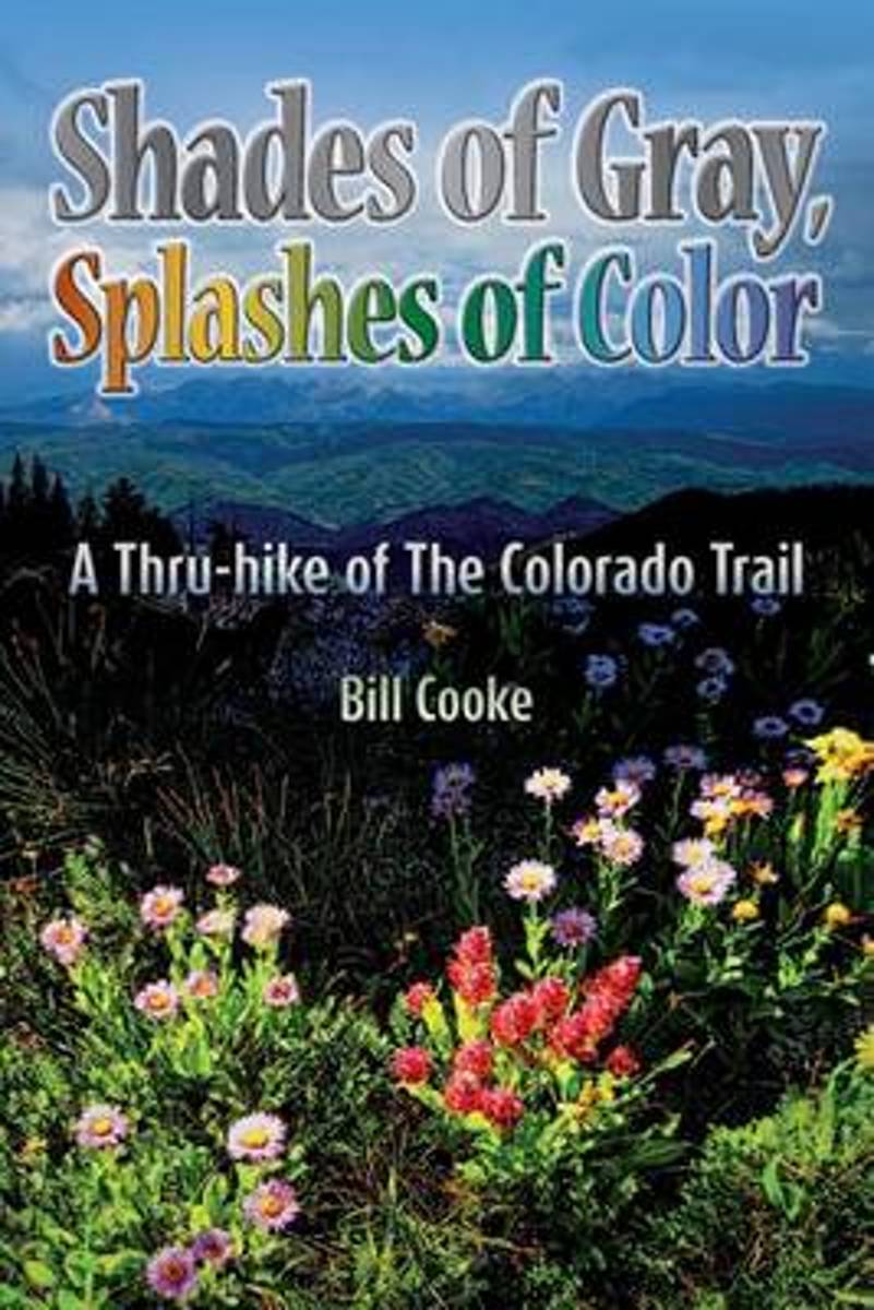
- Shades of Gray, Splashes of Color
- A Thru-hike of The Colorado Trail Lire la suite
- Also available from:
- Bol.com, Netherlands
- Bol.com, Belgium
Bol.com
Netherlands
Netherlands
- Shades of Gray, Splashes of Color
- The Colorado Trail wends its way through the Rocky Mountains of the Centennial State, traversing a landscape as changing and diverse as the swirling afternoon clouds presaging the daily summer thunderstorms. Shades of Gray, Splashes of Color narrates Bill Cookes 2011 hike of this 486-mile trail, the length of which was a personal high for him... Lire la suite
Bol.com
Belgium
Belgium
- Shades of Gray, Splashes of Color
- The Colorado Trail wends its way through the Rocky Mountains of the Centennial State, traversing a landscape as changing and diverse as the swirling afternoon clouds presaging the daily summer thunderstorms. Shades of Gray, Splashes of Color narrates Bill Cookes 2011 hike of this 486-mile trail, the length of which was a personal high for him... Lire la suite
Bol.com
Netherlands
Netherlands
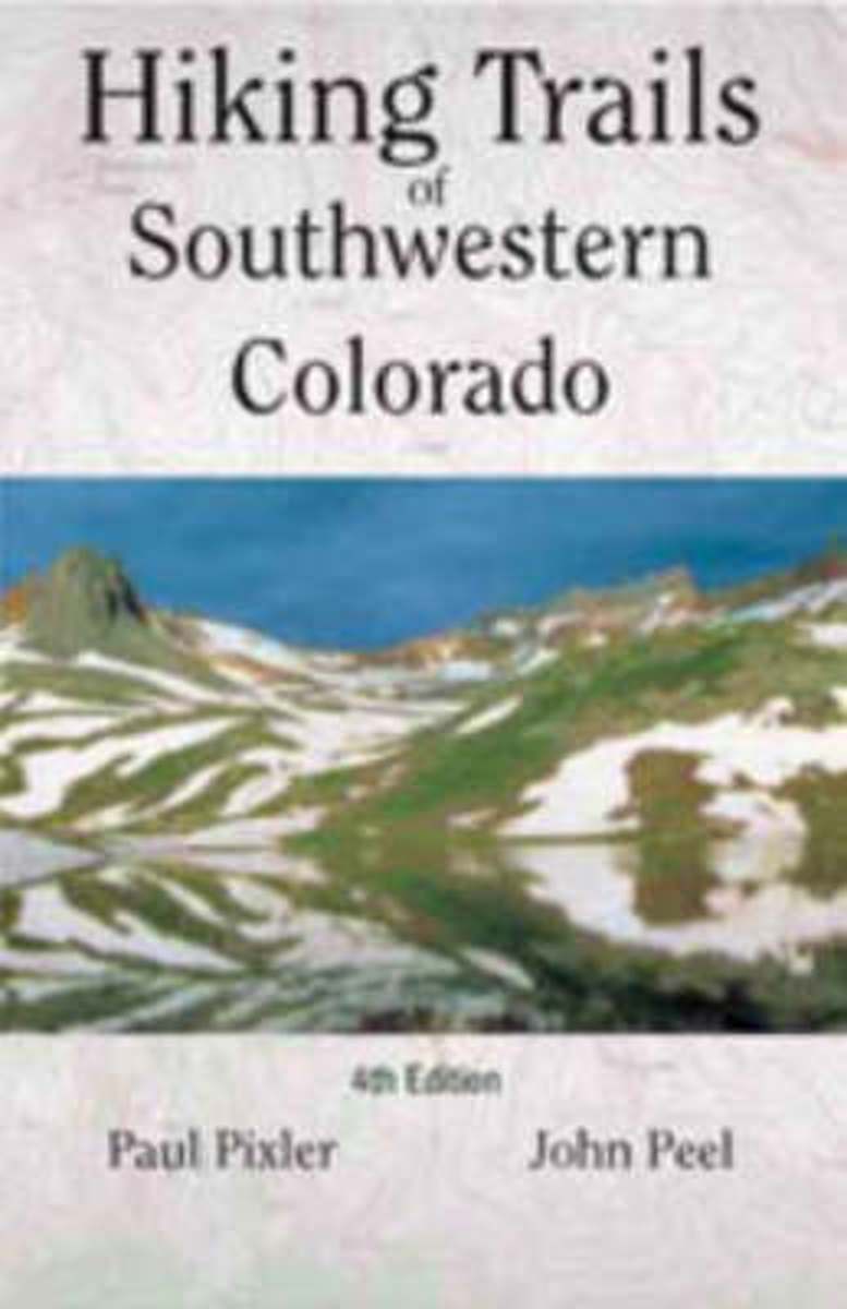
- Hiking Trails of Southwestern Colorado
- The first and second editions of this authoritative guide to Colorado's hiking paradise has been a best-seller among seasoned and beginning hikers for years.This completely revised third edition includes: seventy trips of varying length with corresponding maps, directions to conquer six of Colorado's fourteeners, and sixteen new maps providing... Lire la suite
- Also available from:
- Bol.com, Belgium
Bol.com
Belgium
Belgium
- Hiking Trails of Southwestern Colorado
- The first and second editions of this authoritative guide to Colorado's hiking paradise has been a best-seller among seasoned and beginning hikers for years.This completely revised third edition includes: seventy trips of varying length with corresponding maps, directions to conquer six of Colorado's fourteeners, and sixteen new maps providing... Lire la suite
Cartes

Stanfords
United Kingdom
United Kingdom
- Vall de la Llosa - el Baridà
- Topographic survey of Catalonia at 1:25,000 from the Institut Cartogràfic i Geològic de Catalunya, an attractive alternative to Spain’s national topographic survey at this scale, offering a much larger area per sheet with extensive tourist information and vivid presentation of vegetation and land use.These large, detailed maps have contours at... Lire la suite
Stanfords
United Kingdom
United Kingdom
- Cadí-Moixeró Natural Park West: la Seu d’Urgell - Vall de la Vansa
- Topographic survey of Catalonia at 1:25,000 from the Institut Cartogràfic i Geològic de Catalunya, an attractive alternative to Spain’s national topographic survey at this scale, offering a much larger area per sheet with extensive tourist information and vivid presentation of vegetation and land use.These large, detailed maps have contours at... Lire la suite
Stanfords
United Kingdom
United Kingdom
- Vall de Núria – Ulldeter
- Topographic survey of Catalonia at 1:25,000 from the Institut Cartogràfic i Geològic de Catalunya, an attractive alternative to Spain’s national topographic survey at this scale, offering a much larger area per sheet with extensive tourist information and vivid presentation of vegetation and land use.These large, detailed maps have contours at... Lire la suite
Stanfords
United Kingdom
United Kingdom
- Cadí-Moixeró Natural Park East: el Moixeró - Túnel del Cadí
- Topographic survey of Catalonia at 1:25,000 from the Institut Cartogràfic i Geològic de Catalunya, an attractive alternative to Spain’s national topographic survey at this scale, offering a much larger area per sheet with extensive tourist information and vivid presentation of vegetation and land use.These large, detailed maps have contours at... Lire la suite

Stanfords
United Kingdom
United Kingdom
- El Pont de Suert
- Topographic survey of Catalonia at 1:25,000 from the Institut Cartogràfic i Geològic de Catalunya, an attractive alternative to Spain’s national topographic survey at this scale, offering a much larger area per sheet with extensive tourist information and vivid presentation of vegetation and land use.These large, detailed maps have contours at... Lire la suite
Stanfords
United Kingdom
United Kingdom
- Montsec d’Ares - Congost de Mont-rebei
- Topographic survey of Catalonia at 1:25,000 from the Institut Cartogràfic i Geològic de Catalunya, an attractive alternative to Spain’s national topographic survey at this scale, offering a much larger area per sheet with extensive tourist information and vivid presentation of vegetation and land use.These large, detailed maps have contours at... Lire la suite
Stanfords
United Kingdom
United Kingdom
- Berga - Rasos de Peguera - Gironella - Casserres - Puig-reig
- Topographic survey of Catalonia at 1:25,000 from the Institut Cartogràfic i Geològic de Catalunya, an attractive alternative to Spain’s national topographic survey at this scale, offering a much larger area per sheet with extensive tourist information and vivid presentation of vegetation and land use.These large, detailed maps have contours at... Lire la suite
Stanfords
United Kingdom
United Kingdom
- Puigcerda Llavia la Tossa d`Alp
- Topographic survey of Catalonia at 1:25,000 from the Institut Cartogràfic i Geològic de Catalunya, an attractive alternative to Spain’s national topographic survey at this scale, offering a much larger area per sheet with extensive tourist information and vivid presentation of vegetation and land use.These large, detailed maps have contours at... Lire la suite
Stanfords
United Kingdom
United Kingdom
- La Seu d’Urgell - PN de l’Alt Pirineu
- Topographic survey of Catalonia at 1:25,000 from the Institut Cartogràfic i Geològic de Catalunya, an attractive alternative to Spain’s national topographic survey at this scale, offering a much larger area per sheet with extensive tourist information and vivid presentation of vegetation and land use.These large, detailed maps have contours at... Lire la suite
Stanfords
United Kingdom
United Kingdom
- Alt Cardener - el Port del Comte
- Topographic survey of Catalonia at 1:25,000 from the Institut Cartogràfic i Geològic de Catalunya, an attractive alternative to Spain’s national topographic survey at this scale, offering a much larger area per sheet with extensive tourist information and vivid presentation of vegetation and land use.These large, detailed maps have contours at... Lire la suite
Stanfords
United Kingdom
United Kingdom
- Baixa Ribagorça
- Topographic survey of Catalonia at 1:25,000 from the Institut Cartogràfic i Geològic de Catalunya, an attractive alternative to Spain’s national topographic survey at this scale, offering a much larger area per sheet with extensive tourist information and vivid presentation of vegetation and land use.These large, detailed maps have contours at... Lire la suite
Stanfords
United Kingdom
United Kingdom
- Oliana - del Rialb a la Ribera Salada
- Topographic survey of Catalonia at 1:25,000 from the Institut Cartogràfic i Geològic de Catalunya, an attractive alternative to Spain’s national topographic survey at this scale, offering a much larger area per sheet with extensive tourist information and vivid presentation of vegetation and land use.These large, detailed maps have contours at... Lire la suite
Stanfords
United Kingdom
United Kingdom
- Organyà-Boumort - Serra de Taús
- Topographic survey of Catalonia at 1:25,000 from the Institut Cartogràfic i Geològic de Catalunya, an attractive alternative to Spain’s national topographic survey at this scale, offering a much larger area per sheet with extensive tourist information and vivid presentation of vegetation and land use.These large, detailed maps have contours at... Lire la suite
Stanfords
United Kingdom
United Kingdom
- Tremp - la Pobla de Segur - Serra de Boumort - Isona
- Topographic survey of Catalonia at 1:25,000 from the Institut Cartogràfic i Geològic de Catalunya, an attractive alternative to Spain’s national topographic survey at this scale, offering a much larger area per sheet with extensive tourist information and vivid presentation of vegetation and land use.These large, detailed maps have contours at... Lire la suite

Stanfords
United Kingdom
United Kingdom
- Telluride - Silverton - Ouray - Lake City CO
- Map No. 141, Telluride - Silverton - Ouray - Lake City, CO, in an extensive series of GPS compatible, contoured hiking maps of USA’s national and state parks or forests and other popular recreational areas. Cartography based on the national topographic survey, with additional tourist information.The maps, with most titles now printed on light,... Lire la suite
- Also available from:
- The Book Depository, United Kingdom
- Bol.com, Netherlands
- Bol.com, Belgium
- De Zwerver, Netherlands

The Book Depository
United Kingdom
United Kingdom
- Telluride/silverton/ouray/lake City
- Trails Illustrated Lire la suite

Bol.com
Netherlands
Netherlands
- Telluride/silverton/ouray/lake City
- Waterproof Tear-Resistant Topographic MapExpertly researched and created in partnership with local land management agencies, National Geographic's Trails Illustrated map of Telluride, Silverton, Ouray, and Lake City provides an unparalleled tool for exploring this breathtaking region of Colorado. Whatever the season, you'll find this map... Lire la suite
Bol.com
Belgium
Belgium
- Telluride/silverton/ouray/lake City
- Waterproof Tear-Resistant Topographic MapExpertly researched and created in partnership with local land management agencies, National Geographic's Trails Illustrated map of Telluride, Silverton, Ouray, and Lake City provides an unparalleled tool for exploring this breathtaking region of Colorado. Whatever the season, you'll find this map... Lire la suite

De Zwerver
Netherlands
Netherlands
- Wandelkaart - Topografische kaart 141 Telluride, Silverton, Ouray, Lake City | National Geographic
- Prachtige geplastificeerde kaart van het bekende nationaal park. Met alle recreatieve voorzieningen als campsites, maar ook met topografische details en wandelroutes ed. Door uitgekiend kleurgebruik zeer prettig in gebruik. Scheur en watervast! Beautiful waterproof and tear-resistant topographical hiking map of a well-loved National Park, with... Lire la suite