
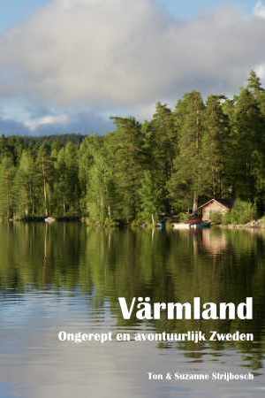
Värmland
Description
Sentiers de cette état
Liens
Données
Rapports
Guides et cartes
Hébergement
Organisations
Voyagistes
GPS
Autre
Livres

Stanfords
United Kingdom
United Kingdom
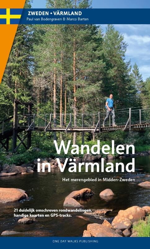
- Walking in Värmland - The Lake Region of Central Sweden
- Walking in Värmland is One Day Walks Publishing`s guide to walking in the picturesque lake region of Central Sweden. A total of 22 walks are included in the guide, ranging in length from 5.5 - 20 kilometres, thus being suitable for a wide range of walking standards. Each walk opens with an Information box detailing details about the walk,... Lire la suite
De Zwerver
Netherlands
2022
Netherlands
2022
Plus de livres …
Cartes

Stanfords
United Kingdom
United Kingdom
- Falun
- Topographic survey of Sweden at 1:100,000, the Vägkartan, from the Lantmäteriet, covering most of the country in 79 double-sided maps. Please note: the mountainous regions of central and northern Sweden are not covered by this series but presented in a separate “Fjällkartan - Mountain Map” series also listed on our website.Each 1:100,000... Lire la suite
Stanfords
United Kingdom
United Kingdom
- Hudiksvall
- Topographic survey of Sweden at 1:100,000, the Vägkartan, from the Lantmäteriet, covering most of the country in 79 double-sided maps. Please note: the mountainous regions of central and northern Sweden are not covered by this series but presented in a separate “Fjällkartan - Mountain Map” series also listed on our website.Each 1:100,000... Lire la suite
Stanfords
United Kingdom
United Kingdom
- Gävle
- Topographic survey of Sweden at 1:100,000, the Vägkartan, from the Lantmäteriet, covering most of the country in 79 double-sided maps. Please note: the mountainous regions of central and northern Sweden are not covered by this series but presented in a separate “Fjällkartan - Mountain Map” series also listed on our website.Each 1:100,000... Lire la suite

Stanfords
United Kingdom
United Kingdom
- Storlien - Blåhammaren Lantmateriet Z52
- Mountain areas of central and northern Sweden on waterproof and tear-resistant, GPS compatible topographic “Fjällkartan” maps at 1:100,000 and 1:50,000 from Lantmäteriet - the country’s national survey organization, with hiking and ski routes, campsites and youth hostels, etc. Relief is shown by contours at 20m intervals and enhanced by relief... Lire la suite
Stanfords
United Kingdom
United Kingdom
- Eskilstuna
- Topographic survey of Sweden at 1:100,000, the Vägkartan, from the Lantmäteriet, covering most of the country in 79 double-sided maps. Please note: the mountainous regions of central and northern Sweden are not covered by this series but presented in a separate “Fjällkartan - Mountain Map” series also listed on our website.Each 1:100,000... Lire la suite

Stanfords
United Kingdom
United Kingdom
- Åre Lantmateriet Z51
- Mountain areas of central and northern Sweden on waterproof and tear-resistant, GPS compatible topographic “Fjällkartan” maps at 1:100,000 and 1:50,000 from Lantmäteriet - the country’s national survey organization, with hiking and ski routes, campsites and youth hostels, etc. Relief is shown by contours at 20m intervals and enhanced by relief... Lire la suite

Stanfords
United Kingdom
United Kingdom
- Storlien - Ljungdalen Lantmateriet Z6
- Mountain areas of central and northern Sweden on waterproof and tear-resistant, GPS compatible topographic “Fjällkartan” maps at 1:100,000 and 1:50,000 from Lantmäteriet - the country’s national survey organization, with hiking and ski routes, campsites and youth hostels, etc. Relief is shown by contours at 20m intervals and enhanced by relief... Lire la suite
Stanfords
United Kingdom
United Kingdom
- Tierp
- Topographic survey of Sweden at 1:100,000, the Vägkartan, from the Lantmäteriet, covering most of the country in 79 double-sided maps. Please note: the mountainous regions of central and northern Sweden are not covered by this series but presented in a separate “Fjällkartan - Mountain Map” series also listed on our website.Each 1:100,000... Lire la suite

Stanfords
United Kingdom
United Kingdom
- Valadalsfjallen Lantmateriet Z53
- Mountain areas of central and northern Sweden on waterproof and tear-resistant, GPS compatible topographic “Fjällkartan” maps at 1:100,000 and 1:50,000 from Lantmäteriet - the country’s national survey organization, with hiking and ski routes, campsites and youth hostels, etc. Relief is shown by contours at 20m intervals and enhanced by relief... Lire la suite
Stanfords
United Kingdom
United Kingdom
- Västerås
- Topographic survey of Sweden at 1:100,000, the Vägkartan, from the Lantmäteriet, covering most of the country in 79 double-sided maps. Please note: the mountainous regions of central and northern Sweden are not covered by this series but presented in a separate “Fjällkartan - Mountain Map” series also listed on our website.Each 1:100,000... Lire la suite

Stanfords
United Kingdom
United Kingdom
- Åre - Vålådalen - Bydalen Lantmateriet Z7
- Mountain areas of central and northern Sweden on waterproof and tear-resistant, GPS compatible topographic “Fjällkartan” maps at 1:100,000 and 1:50,000 from Lantmäteriet - the country’s national survey organization, with hiking and ski routes, campsites and youth hostels, etc. Relief is shown by contours at 20m intervals and enhanced by relief... Lire la suite
Stanfords
United Kingdom
United Kingdom
- Östhammar
- Topographic survey of Sweden at 1:100,000, the Vägkartan, from the Lantmäteriet, covering most of the country in 79 double-sided maps. Please note: the mountainous regions of central and northern Sweden are not covered by this series but presented in a separate “Fjällkartan - Mountain Map” series also listed on our website.Each 1:100,000... Lire la suite

Stanfords
United Kingdom
United Kingdom
- Sylarna - Helags Lantmateriet Z54
- Mountain areas of central and northern Sweden on waterproof and tear-resistant, GPS compatible topographic “Fjällkartan” maps at 1:100,000 and 1:50,000 from Lantmäteriet - the country’s national survey organization, with hiking and ski routes, campsites and youth hostels, etc. Relief is shown by contours at 20m intervals and enhanced by relief... Lire la suite

Stanfords
United Kingdom
United Kingdom
- Sonfjället Lantmateriet Z61
- Mountain areas of central and northern Sweden on waterproof and tear-resistant, GPS compatible topographic “Fjällkartan” maps at 1:100,000 and 1:50,000 from Lantmäteriet - the country’s national survey organization, with hiking and ski routes, campsites and youth hostels, etc. Relief is shown by contours at 20m intervals and enhanced by relief... Lire la suite

Stanfords
United Kingdom
United Kingdom
- Fulufjället Lantmateriet W53
- Mountain areas of central and northern Sweden on waterproof and tear-resistant, GPS compatible topographic “Fjällkartan” maps at 1:100,000 and 1:50,000 from Lantmäteriet - the country’s national survey organization, with hiking and ski routes, campsites and youth hostels, etc. Relief is shown by contours at 20m intervals and enhanced by relief... Lire la suite